ISRO-NASA NISAR Satellite: How the World’s Most Expensive Earth Observation Mission Will Transform India’s Disaster Response
A Billion-Dollar Eye on a Changing Earth
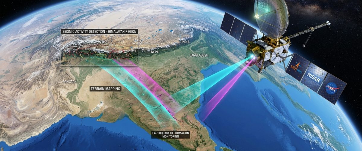
When the ISRO-NASA NISAR satellite lifts off aboard a GSLV-F16 rocket from Sriharikota in the coming months, it will carry with it the hopes of two nations and the promise of fundamentally changing how humanity monitors its planet. The NASA-ISRO Synthetic Aperture Radar — NISAR — is the most expensive Earth observation satellite ever built, with a combined investment exceeding $1.5 billion. More importantly, it represents the most sophisticated collaboration between Indian and American space agencies in history.
NISAR will map the entire globe every 12 days using dual-frequency synthetic aperture radar, producing datasets of unprecedented resolution and consistency. For India, which faces earthquakes, landslides, floods, and coastal erosion with devastating regularity, the satellite promises a quantum leap in disaster preparedness and environmental monitoring capabilities.
The Technology Behind NISAR
NISAR carries two radar systems operating at different frequencies. NASA has provided the L-band radar, which penetrates vegetation canopy and soil to measure ground deformation with millimetre-level precision. ISRO has developed the S-band radar, optimised for monitoring agricultural crops, soil moisture, and ice sheet dynamics. Together, these dual-frequency observations will enable scientists to study phenomena that neither instrument could capture alone.
The satellite’s radar antenna spans 12 metres in diameter — the largest reflector antenna ever launched for an Earth observation mission. This massive aperture enables the satellite to achieve a spatial resolution of 3 to 10 metres across a 240-kilometre swath width, meaning it can detect subtle ground movements across vast areas simultaneously.
ISRO’s contribution extends beyond the S-band radar. The agency has designed and built the spacecraft bus — the structural and electrical backbone of the satellite — along with the launch vehicle. This division of labour reflects a mature partnership where each agency contributes its core strengths.
Earthquake and Landslide Monitoring
India sits atop several active seismic zones, with the Himalayan belt presenting particular vulnerability. The devastating earthquakes in Gujarat (2001) and Nepal (2015) demonstrated the catastrophic consequences of seismic events in densely populated regions with inadequate early warning systems.
NISAR’s L-band radar will continuously measure ground deformation along fault lines, enabling scientists to build detailed strain maps that reveal where tectonic stress is accumulating. While earthquake prediction remains beyond current scientific capability, understanding strain patterns can help identify high-risk zones and improve the probabilistic hazard assessments that inform building codes and urban planning.
Landslide monitoring is equally critical. India recorded over 800 landslide events in 2025 alone, many in the western Himalayas and Western Ghats. NISAR’s ability to detect centimetre-level ground movement on unstable slopes could provide days or weeks of advance warning — enough time to evacuate vulnerable communities. The same technology that powers India’s sovereign AI infrastructure will be essential for processing the enormous data streams that NISAR generates into actionable early warnings.
Agricultural and Water Resource Applications
For a nation where agriculture employs nearly half the workforce, NISAR’s S-band radar offers transformative potential. The satellite can measure soil moisture across India’s agricultural belts with unprecedented frequency and accuracy, enabling precision irrigation scheduling and drought early warning.
ISRO’s existing remote sensing satellites — including Resourcesat and the RISAT series — already support India’s agricultural monitoring programmes. But NISAR’s all-weather, day-and-night radar imaging capability fills a critical gap. Optical satellites are rendered useless by cloud cover, which is pervasive during the monsoon season precisely when agricultural monitoring is most needed. Radar pierces through clouds, ensuring continuous data flow regardless of weather conditions.
The satellite will also monitor groundwater extraction patterns by measuring land subsidence — the gradual sinking of the ground surface caused by excessive pumping. Parts of northern India, particularly Punjab and Haryana, have experienced alarming subsidence rates as agricultural water demands outstrip recharge. NISAR data will provide the scientific foundation for water management policies that balance agricultural productivity with aquifer sustainability.
Climate and Cryosphere Observations
NISAR’s capabilities extend to monitoring the Himalayan glaciers that feed India’s major river systems. These glaciers, which supply water to over a billion people across South Asia, are retreating at accelerating rates due to climate change. NISAR will measure glacier flow velocities and ice sheet dynamics with precision that current satellites cannot match, contributing essential data to climate models that predict future water availability.
Coastal erosion monitoring represents another critical application. India’s 7,516-kilometre coastline supports hundreds of millions of people and some of the country’s most productive economic zones. NISAR will track shoreline changes, mangrove health, and wetland dynamics along this entire coast on a 12-day cycle, providing the data infrastructure needed for climate adaptation planning.
Data Democracy and Capacity Building
In a landmark decision, both NASA and ISRO have agreed to make NISAR data freely available to researchers, governments, and the public worldwide. This open data policy is expected to catalyse innovation across India’s geospatial technology sector, enabling startups and academic institutions to develop applications that ISRO alone could never build.
ISRO has already begun training a cadre of scientists and engineers to process and interpret NISAR data through programmes including the START 2026 space science training initiative. The Gaganyaan human spaceflight programme may capture more headlines, but NISAR’s quiet, continuous observations may ultimately save more lives and livelihoods than any single spectacular mission.
A Partnership for the Planet
NISAR embodies a model of international space cooperation that transcends geopolitical tensions. At a time when space is increasingly viewed through the lens of strategic competition, NISAR demonstrates that shared scientific objectives can produce outcomes that benefit all humanity. For India, it validates the proposition that international partnerships — when structured as genuine collaborations between equals — can accelerate the country’s scientific capabilities far beyond what unilateral effort could achieve.
The satellite may orbit silently overhead, but the knowledge it returns will echo loudly in laboratories, government offices, and farming communities across the subcontinent for decades to come.
- New Heavy Particle Discovered at CERN in 2026: What It Means for the Future of Physics - March 24, 2026
- Gaganyaan 2026: India’s Human Spaceflight Programme Enters Its Most Critical Phase - March 24, 2026
- India’s Semiconductor and AI Surge: How Research Labs Are Powering a Global Transformation - March 24, 2026