NISAR Satellite: How the ISRO-NASA Joint Mission Will Transform Earth Observation and Climate Science

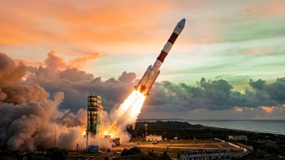
When ISRO’s GSLV-F16 rocket lifts off from the Satish Dhawan Space Centre in Sriharikota later this year carrying the NISAR satellite, it will mark the culmination of one of the most technically sophisticated and scientifically ambitious Earth observation missions ever attempted. The NASA-ISRO Synthetic Aperture Radar mission—born from over a decade of bilateral scientific collaboration—promises to revolutionise our understanding of how the Earth’s surface is changing, with implications that stretch from Himalayan glacier monitoring to global climate science and natural disaster prediction.
A Decade in the Making
The NISAR mission traces its origins to a 2014 agreement between NASA and ISRO that established the framework for building a joint radar observation satellite. The project was conceived as a marriage of complementary capabilities: NASA’s Jet Propulsion Laboratory (JPL) would develop the L-band synthetic aperture radar and contribute high-capacity data systems, while ISRO would build the S-band radar, the spacecraft bus, and provide the launch vehicle. The total investment in the mission is estimated to exceed USD 1.5 billion, making it one of the most expensive Earth observation satellites ever constructed.
The development process has been anything but smooth. Technical challenges in integrating two independently developed radar systems onto a single platform, pandemic-related delays in hardware shipments between the United States and India, and the inherent complexity of building a satellite designed to operate in multiple radar modes simultaneously have pushed the timeline repeatedly. The fact that NISAR has survived these challenges and is now approaching launch readiness is itself a testament to the resilience of the ISRO-NASA partnership.
Dual-Frequency Radar: The Technical Innovation
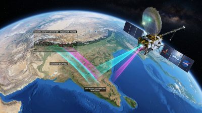
NISAR’s defining technical feature is its dual-frequency synthetic aperture radar system, which operates simultaneously at L-band (1.25 GHz, provided by NASA) and S-band (3.2 GHz, provided by ISRO). This dual-frequency architecture is not merely an engineering convenience—it is a scientific necessity that enables observations impossible with single-frequency systems.
The L-band radar’s longer wavelength can penetrate vegetation canopies and surface soil layers, making it ideal for biomass estimation, subsurface moisture measurement, and detection of ground deformation caused by tectonic activity. The S-band radar, with its shorter wavelength, provides higher-resolution surface detail and is particularly effective for mapping ice sheet structures, urban infrastructure, and agricultural crop conditions.
Together, these two radar systems will generate interferometric measurements capable of detecting surface displacement at the millimetre scale. This extraordinary precision enables NISAR to monitor phenomena that unfold slowly and subtly—land subsidence in coastal cities, creep along fault zones, and the gradual retreat of mountain glaciers—with an accuracy that has never before been achievable from space.
Scientific Objectives: Mapping a Changing Planet
NISAR’s science agenda is organised around three primary objectives, each addressing critical gaps in our understanding of Earth system processes. The first focuses on ecosystem disturbances—quantifying changes in forest biomass, wetland dynamics, and agricultural land use that affect the global carbon cycle. Current estimates of terrestrial carbon stocks carry large uncertainties that limit the accuracy of climate models; NISAR’s systematic biomass measurements are expected to reduce these uncertainties significantly.
The second objective centres on ice sheet and glacier dynamics. NISAR will measure the velocity and structural changes of polar ice sheets and mountain glaciers with unprecedented temporal frequency, mapping the entire land and ice surface of the Earth every twelve days. For India, this capability is particularly consequential. The Hindu Kush Himalayan glacial system—sometimes called Asia’s water tower—feeds rivers including the Ganges, Indus, and Brahmaputra that sustain the agricultural and domestic water needs of over a billion people across South Asia.
The third objective addresses natural hazards. NISAR’s interferometric capabilities will enable precise mapping of ground deformation associated with earthquakes, volcanic activity, and landslides. India, which sits on seismically active plate boundaries and faces recurrent monsoon-triggered landslides, stands to benefit enormously from this early warning and hazard assessment capability. India’s broader environmental monitoring ecosystem—discussed in the context of India’s AI Summit 2026 and the structural gaps exposed and the intersection of AI with Earth sciences—will integrate NISAR data into increasingly sophisticated prediction models.
India’s Strategic Gains from the Partnership
Beyond its scientific value, NISAR delivers significant strategic benefits to India’s space programme. The mission demonstrates ISRO’s capacity to develop and deliver radar technology at the cutting edge of global capability—the S-band SAR instrument represents a major technological achievement for India’s space electronics industry. This expertise has direct applications in defence surveillance, maritime domain awareness, and intelligence gathering.
The partnership also provides ISRO’s engineers with invaluable experience in managing a complex international space project. The protocols for joint mission planning, shared data management, cross-border hardware integration, and coordinated mission operations developed through NISAR will inform future collaborative ventures with space agencies across Europe, Japan, and the emerging space nations of the Indo-Pacific region.
Furthermore, NISAR establishes India as a co-equal partner in one of the decade’s marquee science missions, enhancing the country’s standing in the global Earth observation community. Access to NISAR’s full data archive—which will be made freely available to researchers worldwide—positions Indian scientists at the forefront of synthetic aperture radar applications research, with potential spinoffs in precision agriculture, urban planning, and climate adaptation planning.
Data Democratisation and the Open Science Paradigm
One of NISAR’s most progressive design features is its commitment to open data access. Both NASA and ISRO have agreed that the mission’s entire data archive will be freely accessible to any researcher or organisation worldwide, without embargo periods or access restrictions. This open science approach, while standard practice for NASA missions, represents a significant departure for ISRO, which has historically maintained tighter control over its Earth observation data products.
The anticipated data volume is staggering. NISAR is expected to generate approximately 26 terabytes of data per day—more than any previous Earth observation mission. Processing, archiving, and distributing this data torrent will require substantial ground infrastructure investments by both agencies. ISRO is establishing dedicated NISAR data processing centres in India, while NASA’s Alaska Satellite Facility will serve as the primary archive for the global research community.
For India’s rapidly growing geospatial industry, the free availability of NISAR data represents an enormous commercial opportunity. Startups and established firms specialising in geospatial analytics, agricultural technology, and urban planning will be able to build value-added products and services atop NISAR’s systematic observations, potentially catalysing an entirely new segment of India’s digital economy.
Challenges Ahead: Integration and Launch Readiness
As NISAR moves through its final integration and testing phases ahead of the planned GSLV-F16 launch, several technical and logistical challenges remain. The satellite’s mass—approximately 2,800 kilograms—pushes the GSLV Mark II to the upper limits of its geostationary transfer orbit delivery capability, leaving minimal performance margin. Any integration anomalies or weight growth could potentially necessitate mission design adjustments.
The thermal and electromagnetic compatibility of the dual-frequency radar system also presents ongoing engineering challenges. Operating two powerful radar transmitters simultaneously on a single platform creates complex interference patterns that must be carefully managed to ensure data quality. The extensive ground testing programme has addressed these concerns, but the transition from laboratory conditions to the orbital environment always introduces uncertainties.
Despite these challenges, both NASA and ISRO have expressed confidence in meeting the 2026 launch window. The mission’s completion will not only deliver transformative scientific capability but will also stand as a powerful demonstration of what international space cooperation can achieve when sustained commitment, technical excellence, and shared scientific purpose converge toward a common objective.
- ISRO and AIIMS Sign Landmark MoU for Space Medicine Research Ahead of Gaganyaan Mission - March 25, 2026
- Rising Temperatures Reshape Wildlife Behaviour Across India as Scientists Sound Climate Alarm - March 25, 2026
- UPI Crosses 800 Million Daily Transactions as CRED Gets Payment Aggregator Licence From RBI - March 25, 2026