Mumbai Records Season’s First Heavy Pre-Monsoon Rainfall — Why the City Got Drenched Before the Monsoon Arrived
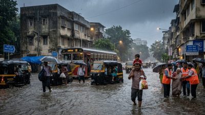
Mumbai woke up on Wednesday, 3 June 2026, to the season’s first proper pre-monsoon rains — heavy showers that swept across the city from early morning, flooding low-lying areas, snarling traffic on arterial roads, and offering dramatic relief from weeks of suffocating heat and humidity. The India Meteorological Department (IMD) confirmed that the southwest monsoon had not yet officially arrived in Mumbai, raising the obvious question: why was it raining this heavily without the monsoon?
What Happened on June 3
The showers began around 5:30 a.m. and continued intermittently through mid-afternoon, with some areas of the city recording over 50 mm of rainfall within a few hours. The island city (south Mumbai), the western suburbs from Bandra to Andheri, and parts of Navi Mumbai received the heaviest spells. The eastern suburbs and Thane district saw lighter but sustained rainfall.
Waterlogging was reported from predictable low-lying areas: Hindmata in Dadar, Sion’s King Circle, the Milan subway in Santacruz, and stretches of the Western Express Highway near Malad. The Brihanmumbai Municipal Corporation (BMC) activated its monsoon-preparedness infrastructure — pumping stations, de-silted storm water drains, and disaster response teams — despite the monsoon not having officially arrived.
Traffic on the Western Express Highway, Eastern Express Highway, and the Sion-Panvel highway slowed to a crawl during morning rush hour. Local train services — Mumbai’s lifeline — operated with minor delays of 10 to 15 minutes, though no services were suspended. The Mumbai Metro lines remained unaffected.
The Science Behind Pre-Monsoon Rain
Pre-monsoon rainfall in coastal cities like Mumbai is a well-understood atmospheric phenomenon, but its timing and intensity vary from year to year. The science involves several interacting processes that can produce heavy rain even before the southwest monsoon establishes itself over the region.
India’s weather is shaped by massive seasonal shifts in temperature and wind patterns. As summer intensifies between April and June, land surfaces heat up dramatically — particularly across northern and central India. The hot air above the land rises, creating a low-pressure zone that draws moist air from the surrounding oceans inward. This process gradually builds the southwest monsoon system, which typically reaches Kerala by late May or early June and Mumbai by mid-June.
But before this large-scale atmospheric circulation fully engages, local-scale weather processes can generate heavy rainfall. Mumbai’s pre-monsoon showers are primarily caused by three mechanisms working together.
First, convective instability: Weeks of temperatures above 35°C heat the city’s surface and the Arabian Sea along its coast. Warm, moisture-laden air near the surface becomes buoyant and rises rapidly. As it ascends, it cools, the moisture condenses into towering cumulonimbus clouds, and heavy rain — often accompanied by thunder and lightning — follows. These convective storms are intense but localised, which is why different parts of Mumbai can receive very different amounts of rainfall on the same day.
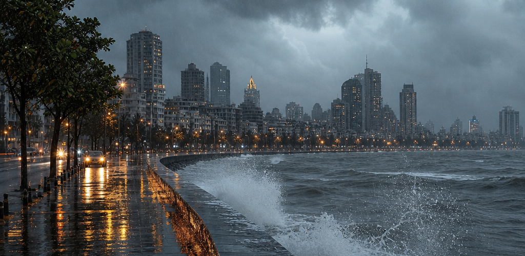
Second, sea breeze convergence: Mumbai sits on a narrow peninsula flanked by the Arabian Sea on three sides. During the afternoon, sea breezes carrying moist maritime air push inland and collide with warmer air flowing off the land. This convergence zone acts as a lifting mechanism that triggers cloud formation and precipitation, particularly along the western coastline.
Third, upper-level troughs and weather disturbances: Large-scale weather patterns in the upper atmosphere can create additional lift. A trough — a zone of relatively low pressure at altitudes of 5 to 10 kilometres — was positioned over the western Indian coast on 3 June, enhancing the instability caused by surface heating and sea breezes. When these three factors align, the result can be rainfall that approaches monsoon-like intensity.
How Pre-Monsoon Rain Differs from the Actual Monsoon
Despite the heavy showers, pre-monsoon rain and the actual southwest monsoon are fundamentally different weather phenomena. The monsoon is a sustained, large-scale reversal of wind patterns that brings weeks to months of continuous rainfall. Pre-monsoon rain is episodic — driven by local heating and short-lived instability rather than the continental-scale pressure differences that power the monsoon.
The IMD defines the monsoon’s arrival over a specific location using criteria that include sustained rainfall over consecutive days, a persistent shift in wind direction to southwesterly, and characteristic changes in atmospheric humidity at multiple altitudes. A single day of heavy pre-monsoon rain, no matter how intense, does not meet these criteria.
The southwest monsoon hit Kerala on 4 June, according to the IMD, and is expected to progress northward to reach Mumbai between 11 and 15 June — roughly on schedule. The pre-monsoon showers of 3 June were, in effect, the atmosphere’s trailer before the main feature.
Why Mumbaikars Should Not Be Complacent
The pre-monsoon showers offered a useful stress test for Mumbai’s flood preparedness systems — and the results were mixed. The BMC has invested over Rs 3,000 crore in storm water drain upgrades, pumping stations, and flood mitigation infrastructure since the catastrophic floods of July 2005 (when Mumbai received 944 mm of rain in 24 hours). The new Brihanmumbai Storm Water Disposal System (BRIMSTOWAD) project has expanded drainage capacity in several chronic flooding zones.
Yet waterlogging from just 50 mm of pre-monsoon rain suggests that capacity gaps remain. When the monsoon arrives in full force and dumps 200-300 mm in a day — which happens multiple times each season — the same low-lying areas that flooded on 3 June will face far more severe inundation.
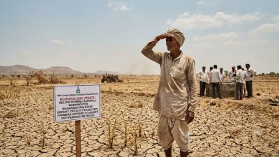
Climate scientists have noted that Mumbai’s pre-monsoon rainfall has been increasing in intensity over the past decade, consistent with global warming trends that enhance atmospheric moisture content. Warmer oceans produce more evaporation, which means more water vapour available for precipitation events. A city that is already vulnerable to flooding can expect these episodes to become more frequent and more intense.
What IMD Says About the Coming Monsoon Season
The IMD has forecast a normal monsoon for 2026, with total seasonal rainfall expected at 96 to 104 percent of the Long Period Average. However, the forecast carries caveats. The developing El Niño conditions in the Pacific Ocean — while not yet fully formed — could suppress rainfall in the latter half of the monsoon season (August-September), potentially creating a dry spell after a wet June-July start.
For Mumbai specifically, the IMD’s regional forecast indicates above-normal rainfall in June and July, followed by a possible dip in August. The monsoon’s behaviour over the Arabian Sea will be critical — any cyclonic disturbances forming in the sea could dramatically boost rainfall totals for the city.
The June 3 pre-monsoon showers, while disruptive, served as a reminder that Mumbai’s relationship with water is defined by extremes — too much heat followed by too much rain, with infrastructure that struggles to handle either. The monsoon is coming, and the city has roughly two weeks to ensure its preparations match the challenge.
- India’s Startup Funding Crosses $7.2 Billion in H1 2026 - July 1, 2026
- After Ireland Shock, India’s T20I Side Faces Bigger Test - July 1, 2026
- Ireland Stun World Champions India 2-0 in Belfast, Sooryavanshi Debate Rages On - June 29, 2026