NASA-ISRO NISAR Satellite Reveals Mexico City Is Sinking at 14 Inches Per Year in Groundbreaking Radar Mapping
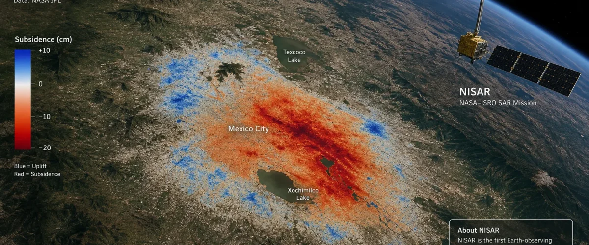
The NISAR satellite — a collaborative mission between NASA and the Indian Space Research Organisation (ISRO) — has produced groundbreaking radar imagery revealing that Mexico City is sinking at an alarming rate of approximately 14 inches (35 centimetres) per year. The data, collected between 25 October 2025 and 17 January 2026 and published by NASA’s Jet Propulsion Laboratory in late April, confirms that NISAR’s dual-band radar instruments are performing as intended and delivering unprecedented detail on land surface changes.
The subsidence maps, created using NISAR’s L-band radar instrument, show dark blue areas sinking by more than half an inch (over 2 centimetres) per month. The sinking is primarily caused by decades of excessive groundwater pumping, which has led to the compaction of the ancient lakebed on which Mexico City was built. This is the same geological process that has caused buildings across the capital to tilt and roads to crack — a crisis that affects more than 21 million residents in the greater metropolitan area.
What Is the NISAR Satellite?
NISAR stands for NASA-ISRO Synthetic Aperture Radar. Launched in 2025, it is the first satellite ever to carry two SAR (Synthetic Aperture Radar) instruments operating at different wavelengths. The L-band radar, developed by NASA, operates at a 24-centimetre wavelength that can penetrate dense vegetation such as forest canopies. The S-band radar, developed by ISRO’s Space Applications Centre, uses a 10-centimetre wavelength that is more sensitive to smaller vegetation, making it effective for monitoring agriculture and grassland ecosystems.
The satellite is designed to map the entire Earth’s surface every 12 days, providing a continuous stream of data that scientists can use to track changes in ice sheets, forests, wetlands, agricultural lands, and urban areas. The mission represents one of the most significant collaborations between NASA and ISRO, with a combined investment of approximately $1.5 billion.
Mexico City’s Subsidence Crisis: The Full Picture
Mexico City’s sinking problem has been documented for decades, but the NISAR data provides the most detailed and comprehensive view yet of the scale of the crisis. The city was built on the drained bed of Lake Texcoco by Spanish colonists in the 16th century, and the soft, clay-rich soil has been compacting ever since as groundwater is extracted to supply the growing population.
The rate of subsidence varies across the metropolitan area. The historic centre, home to the iconic Palacio de Bellas Artes and the Metropolitan Cathedral, is sinking at a moderate rate of about 10 centimetres per year. But in the eastern and southeastern neighbourhoods, where aquifer extraction is most intense, sinking rates exceed 30 centimetres annually — nearly an inch per month.
The consequences are severe. Water and sewage pipes fracture regularly, buildings develop dangerous structural faults, and the city’s flood risk increases as the ground level drops relative to surrounding hills. The cost of infrastructure repairs runs into billions of dollars annually, and scientists have warned that without significant changes to water management practices, parts of the city could become uninhabitable within decades.
Why NISAR’s Data Matters
Previous satellite missions, including the European Space Agency’s Sentinel-1, have tracked Mexico City’s subsidence, but NISAR offers several advantages. Its dual-band configuration provides complementary data sets that allow scientists to distinguish between different types of ground movement — such as subsidence caused by groundwater extraction versus movement caused by tectonic activity or construction.
The L-band radar’s ability to penetrate vegetation means it can map ground deformation in areas where optical satellites and shorter-wavelength radars struggle. This is particularly valuable in tropical and subtropical regions, where dense plant cover can obscure ground-level changes. Mexico City’s remaining green spaces and periurban areas, for example, are now being monitored with a level of precision that was previously impossible.
NISAR also has a much shorter revisit time than many previous missions, allowing researchers to track changes on a near-monthly basis rather than waiting months or years between observations. This rapid cadence is critical for early warning systems and for helping authorities identify areas where subsidence is accelerating.
India’s Growing Role in Global Earth Observation
The NISAR mission underscores India’s expanding capabilities in space technology and Earth observation. ISRO’s S-band radar instrument aboard the satellite is a significant technological achievement, and the agency’s contribution to the mission has been widely praised by the international scientific community.
India’s space programme has achieved several milestones in recent months. India’s private space sector has also been achieving milestones, with startups like GalaxEye launching the world’s first OptoSAR satellite. Meanwhile, ISRO continues to advance its plans for a 55-satellite military constellation for round-the-clock defence surveillance.
For the global scientific community, NISAR’s early results from Mexico City represent just the beginning. The satellite is expected to operate for at least three years, during which time it will produce the most comprehensive radar-based map of Earth’s surface ever created. Data from the mission will be freely available to researchers and space agencies worldwide, reflecting the open-data ethos that has defined both NASA and ISRO’s approach to Earth observation.
What Comes Next
Scientists are now using NISAR data to study subsidence in other cities worldwide, including Jakarta, Bangkok, and several Indian coastal cities where groundwater depletion is a growing concern. The satellite’s findings are expected to inform policy decisions on water management, urban planning, and climate adaptation across dozens of countries.
For Mexico City, the NISAR data adds urgency to calls for a fundamental rethinking of the city’s water supply strategy. Experts have long advocated for reduced groundwater extraction, expanded rainwater harvesting, and investment in alternative water sources such as desalination and water recycling. Whether the city’s leaders will act on the increasingly stark scientific evidence remains an open question — but thanks to NISAR, the scale and pace of the crisis can no longer be ignored.
The mission’s success is also a testament to the power of international collaboration in scientific research. As both NASA and ISRO plan their next generation of Earth observation satellites, the NISAR experience will serve as a model for how two of the world’s most ambitious space agencies can work together to address the planet’s most pressing challenges.