IMD Issues Red Alert: Extremely Heavy Rainfall Warning for Northeast India and Bengal Till June 25
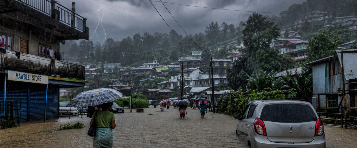
The India Meteorological Department (IMD) has issued a red alert for extremely heavy rainfall across northeastern India and sub-Himalayan West Bengal and Sikkim, warning that torrential downpours will continue until June 25 — a five-day deluge that threatens to trigger flooding, landslides, and widespread disruption across one of India’s most vulnerable regions. The warning comes even as large parts of central and western India continue to experience a significant monsoon deficit.
The IMD’s press release, issued on June 21, forecasts “very heavy to extremely heavy rainfall” — defined as over 204.5 mm in 24 hours — across Assam, Meghalaya, Arunachal Pradesh, Nagaland, Manipur, Mizoram, Tripura, and sub-Himalayan West Bengal. Sikkim, which has experienced devastating floods and landslides in recent years, is on particular alert.
What’s Driving the Rainfall
The extreme rainfall in the northeast is being driven by a convergence of meteorological factors:
Monsoon Trough Position: The monsoon trough — the belt of low pressure along which the heaviest monsoon rainfall occurs — is currently positioned along the sub-Himalayan region and the northeast, channelling massive amounts of moisture from the Bay of Bengal directly into the mountainous terrain of the region. The orographic lifting effect — where moisture-laden winds are forced upward by mountains — intensifies rainfall dramatically.
Related: Monsoon Marches On: IMD Says Southwest Monsoon to Cover Maharashtra, Bihar by June 23
Active Monsoon Phase: While the overall monsoon has been sluggish — with a 40% nationwide deficit — the northeast has entered a hyperactive phase where rainfall rates far exceed normal levels. This spatial imbalance is a characteristic of weak monsoon years, where rainfall concentrates in certain regions rather than distributing evenly across the subcontinent.
Bay of Bengal Moisture Feed: A persistent low-pressure area over the northern Bay of Bengal is pumping moisture into the northeast at rates significantly above the seasonal average. This moisture feed, combined with the topographical amplification of the region’s hills and valleys, creates conditions for extreme rainfall events.
The Risks
The IMD’s red alert carries specific implications for several categories of risk:
Flooding: The Brahmaputra river system — which drains much of northeastern India — is expected to see rising water levels. Assam, which experiences catastrophic floods almost annually, is on high alert. The state disaster management authority has activated emergency protocols, including the pre-positioning of rescue boats, the opening of relief camps, and the deployment of NDRF teams to flood-prone districts.
Landslides: The mountainous terrain of Sikkim, Arunachal Pradesh, and Meghalaya is highly susceptible to landslides during periods of extreme rainfall. Several major highways in the region — including the strategically important routes connecting India’s northeastern states to the rest of the country — could be blocked by landslides, disrupting supply chains and isolating communities.
Agriculture: While the northeast contributes a smaller share of India’s total agricultural output compared to the Gangetic plains, the region’s tea plantations, rice paddies, and horticultural crops are vulnerable to waterlogging and flood damage.
The Monsoon Paradox
The IMD’s extreme rainfall warning for the northeast exists alongside a troubling monsoon deficit across central and western India. The nationwide rainfall deficit of approximately 40% reflects a monsoon that has been geographically uneven — dumping excessive rainfall in the northeast while leaving Maharashtra, Madhya Pradesh, and Rajasthan waiting for sustained rains.
The IMD has forecasted that the monsoon will advance rapidly into Maharashtra, Telangana, Odisha, Jharkhand, and Bihar around June 23 — a development that, if it materialises, could begin narrowing the deficit. The next 48 to 72 hours will be critical in determining whether the 2026 monsoon season recovers its balance or continues its lopsided pattern.
Also Read
- Southwest Monsoon Advances Into West Bengal and Bihar — IMD Issues Wet Spell Warning for Northwest India
- Southwest Monsoon Advances Rapidly: IMD Forecasts Above-Normal Rainfall for Most of India in Coming Weeks
- India’s Monsoon 2026 Forecast Drops to 90% of Normal — El Niño Threatens Agriculture and Economy as IMD Issues Below-Normal Warning
- Super El Nino 2026 Threatens India Southwest Monsoon as IMD Forecasts Below-Normal Rainfall and Drought Risk Looms Over 60 Percent Farmers
- Monsoon Alarm: India Faces 40% Rainfall Deficit as Southwest Monsoon Stalls